
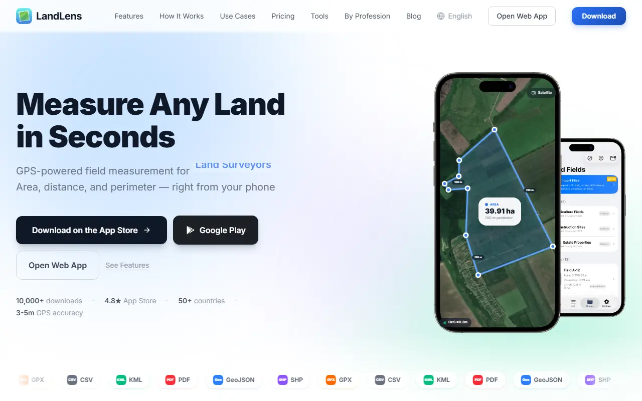
About LandLens
LandLens is a land measurement app for iPhone, Android and the web. You can walk a boundary with GPS tracking or tap pins on a satellite map, and it calculates area, perimeter and distance in real time, switchable between units such as acres, hectares, square meters and square feet. It targets farmers, land surveyors, real estate professionals, engineers, landscapers, architects, construction teams and outdoor users such as hunters.
Measurements can be organized in color-coded folders for farms, sites or properties and exported as KML, KMZ, GeoJSON, PDF and Shapefile, with GPX and CSV also shown, so they can be shared or opened in GIS software. The app works offline in the field and syncs when a connection returns, and cloud sync keeps data available across devices.
Typical uses listed include measuring crop fields and planning irrigation, documenting property lines, checking lot sizes for listings, estimating excavation and mapping trails or conservation areas. LandLens has a pricing page and a library of tools by profession and blog articles.
Key features
- Area, distance and perimeter by GPS walk
- Tap-to-pin measurement on a satellite map
- Export to KML, KMZ, GeoJSON, PDF and Shapefile
- Color-coded folders for properties and sites
- Offline use with later sync
- Cloud sync across devices
- Web app alongside mobile apps
Good fit for
- Farmers measuring fields for planning inputs
- Surveyors and agents documenting property boundaries
LandLens: questions and answers
- What is LandLens used for?
- LandLens is a mobile and web app for measuring land area, distance and perimeter by walking a boundary or marking a satellite map, with GIS-ready exports. It is a good fit for farmers measuring fields for planning inputs, and surveyors and agents documenting property boundaries.
- Is LandLens free?
- Yes. LandLens has a free plan.
- Is LandLens open source?
- No. LandLens is proprietary (closed-source) software and can't be self-hosted. In the Maps & Navigation category, open-source options include Organic Maps, OpenStreetMap and Dawarich.
- What are some alternatives to LandLens?
- LandLens competes with Google Earth.
Open-source alternatives to LandLens
See all
Organic Maps
Maps & Navigation
🍃 Organic Maps is a free Android & iOS offline maps app for more than 6M travelers, touri
OSSvs Google Maps★ 16k
OpenStreetMap
Maps & Navigation
The Rails application that powers OpenStreetMap
GPL-2.0vs Google Maps★ 2.8k
Dawarich
Maps & Navigation
The private alternative to Google Timeline. Import your location history, keep it forever.
AGPL-3.0★ 11k
OsmAnd
Maps & Navigation
OsmAnd
OSSvs Google Maps★ 6.1k
Wanderer
Maps & Navigation
wanderer is a self-hosted trail database. Save your adventures!
AGPL-3.0vs Komoot★ 4k
iD
Maps & Navigation
🆔 The easy-to-use OpenStreetMap editor in JavaScript.
ISC★ 3.9k
SaaS alternatives to LandLens
See all
Google Earth
Maps & Navigation
3D globe and satellite imagery viewer from Google
SaaS
Nearmap
Maps & Navigation
High-resolution aerial imagery and location data subscription service
SaaS
CalTopo
Maps & Navigation
Web mapping and route planning tool for backcountry and search-and-rescue teams
SaaS
CoPilot GPS
Maps & Navigation
Offline GPS navigation app for cars, trucks and RVs
SaaS
Magic Earth
Maps & Navigation
Free offline navigation app with turn-by-turn directions and traffic
SaaS
Ride with GPS
Maps & Navigation
Route planning, navigation and tracking platform for cyclists
SaaS